IRELAND - ARAN ISLANDS, INIS OÍRR


The building stands in Ballyvaughan, next to the harbour. The port played an important role in the transportation of coal, medicine, and food. The Monks' building was the land-based distributor in the past.

After the small fishing village, we once again travelled a section of the Wild Atlantic Way, because the view is never enough to get tired of. The landscape had a completely different atmosphere this time: a cold wind and gloomy clouds gave a taste of Burren's climate. The previous days' t-shirt/shorts outfit was replaced by a windbreaker/sweater.

The Murrooghtoohy Geopark is located at the tip of Galway Bay. We can take a fantastic hike on the rocks, from the road all the way to the sea. The area was covered with soil, trees, lakes, and swamps 6000 years ago. During the years the hairline cracks of the rocks widened into distinct fissures over millions of years, creating this unique surface pattern.

The smaller and larger rocks are also evidence of the Ice Age, while the vertically stacked stones are a testament to human craftsmanship. The stone walls appear not only here but throughout the entire Burren area, and their role is closely related to the weather: their function is to provide better, wind-sheltered conditions for grazing animals.


Since the weather forecast did not predict rain for the next day, we decided to take a ferry to one of the Aran Islands. The three islands differ in character and size. Inis Mór is the largest, Inis Oírr is the smallest, and it is the closest to the shores of Doolin (about 15 minutes). In June, there was no boat to Inis Meáin Island.
The islands rest on limestone foundations that are approximately 350 million years old, formed in shallow waters from the accumulation of shells and other marine organisms, creating sedimentary layers. The first people, likely arriving from the mainland of Ireland, settled the islands around 3000 BC and built with stone. The second major settlement occurred during the Bronze Age, followed by the Iron Age and the arrival of the Celts. In the 6th century, Christianity appeared. According to legend, it was Enda's sister who convinced him to dedicate his life to God, which is why he travelled to Scotland, where he was ordained as a priest. After returning to Ireland, he established a monastic community following an ascetic rule on the Aran Islands.
Saint Enda and the monks, in addition to their religious duties, engaged in scholarly work, taught, copied manuscripts, and produced books.
The combined effect of the harsh conditions and isolation from the mainland has led the inhabitants to develop a unique way of life and Irish identity.
Additionally to some famous writers of the islands (Máirtín Ó Direáin and Liam O Flaherty), many poets and writers travelled here to find the Irish roots and the ancient culture they believed to be lost.

Once again, we bought the ticket for the boat online the day before and set off on our 15-minute journey, looking forward to the experience of the Cliffs of Moher. The destination was the smallest island, Inis Oírr (Inisheer). As I mentioned, the weather turned harsher, but this wasn't apparent near the shore. A little further away, yes :-(. Some of the passengers got sick, while others got soaked by the high waves. Some were measuring their blood pressure non-stop out of nervousness, and there were - a few - who really enjoyed the stormy sea. This short trip also proved how small we are on the stage of nature. There were hardly any waves, but those that were there hit the ship with tremendous force and tossed it around.
On the way back, while waiting at the port, we talked to one of the sailors about how "great" our trip had been. He suggested we come back in winter, then we would know what sailing in windy weather is really like.

Inis Oírr can be explored in a few hours - by bicycle, minibus, or horse-drawn carriage. We arrived around 1 PM and focused on the main sights, as the last boat back to Doolin left at 4:45 PM. (the first one departs from there at 10:00 AM - June 2025 data).
What struck me at first glance was that compared to the mainland, there are significantly more stone fences here, and the areas they enclose are smaller.
The hardness of the island was softened by the colourful houses and the green grass. Everywhere you could feel that life is no walk in the park here. The "fertile" soil is the result of centuries of hard work: layer by layer, they transformed the rocky surface into agricultural land by adding seaweed. Although the flora and fauna are rich, daily life is a struggle. Fishing is of extreme significance, the Aran wool sweaters are world-famous, they sell seaweed to the beauty industry, and of course, tourism is also present as a source of income.

Our walking journey was quite chaotic. Although there are numbers on the roads for cyclists - I assume indicating which route they are on - the signage for the island's attractions and more detailed information is almost non-existent.
At first, we headed in the wrong direction. In other words, there is no wrong direction, but if you don't have much time, every minute counts.
The first sight was an "exhibition" about the holy springs of the Aran Islands. There are several of these, and they play an important spiritual role. Besides looking at the pictures, no other information about the place was revealed.

After that, we set off towards Teampall Chaomhan (St. Caomhán's Church or "Sunken" church), which is surrounded by the island's main cemetery. The interesting thing about the church is that it looks as if it has been sunk into the ground. According to legend, the Irish monk and missionary Caomhan likely visited the island in the 6th century. He lived a lonely and quiet life, spending most of his time in meditation and prayer. He is also the patron saint of the island's fishermen. According to tradition, Caomhan's grave has healing powers. When the sea was stormy, the families of sailors sprinkled white sand from his grave onto the waves to ensure their loved ones returned safely from the sea.

Next to the cemetery is the airport. Yes, this small island also has an airport. It's not big and not for large planes, but it exists and it works!

From the church, we walked up to O’Brien’s Castle. In front of the castle, an earthen rampart stood at the highest point of the island. This fortress was built between AD 600 and AD 100. The castle was built by a branch of the O’Brien family in the early 1400s, and later came into the ownership of the Ó Flaithbheartaigh (O’Flaherty) family. Cromwell's army captured and destroyed the castle during the occupation of Ireland, thereby depriving it of its military and strategic role. The building has been uninhabited and in ruins ever since.
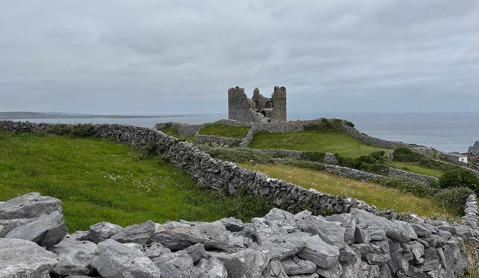

Behind the castle, in the distance, one could see the island's black-and-white striped lighthouse, but we didn't go there. The Plassey shipwreck seemed more interesting.

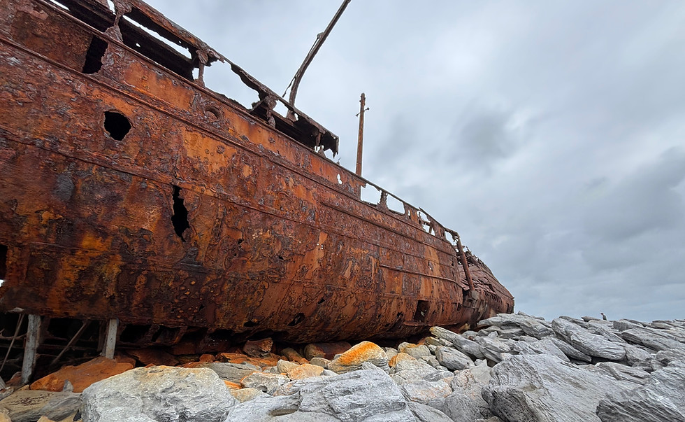
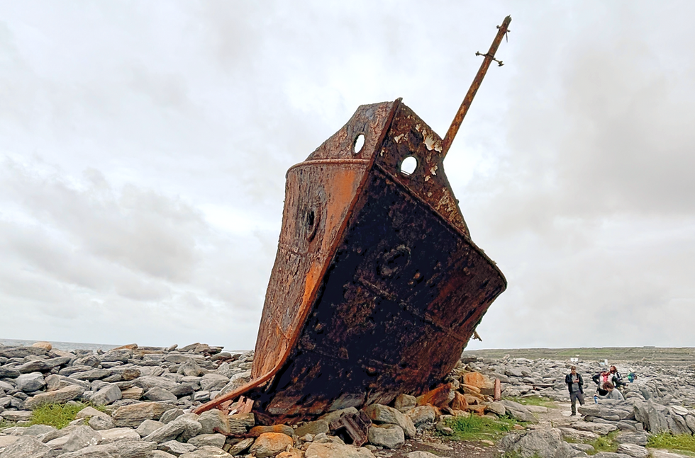
The Royal Navy's HMS Juliet, which served as a minesweeper during World War II, was converted for commercial service in 1945 and renamed Peterjon. In 1951, the Limerick Steamship Company acquired the 53m long and 600-ton ship, and it was then renamed Plassey. In 1960, during a commercial voyage, the ship was transporting whisky, yarn, and stained glass windows from Kerry to Galway when it struck the Finnis Rock near Inis Oírr in a severe storm. The islanders rescued the eleven crew members and a few weeks later removed the ship from the rocks and brought it to the shore of Inisheer. The shipwreck has since been moved twice: once in 1991 and then in 2014, both times due to storms.

It's breathtaking how it stands there alone by the sea, among the rocks. Rust has corroded it, staining its earthy bed red. Getting quite close, we can feel its impressive size.
The boat trip back from the island wasn't any less turbulent, but we already knew what to expect. The last day of our week-long trip was an appropriate ending to our adventures in Ireland. From every perspective - timing, weather, location, sights - we had a perfect week without any feeling of missing out, and we also had confidence that we would definitely return to Ireland.
June, 2025


